Property Record
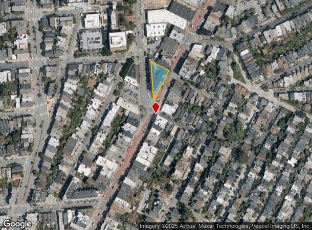
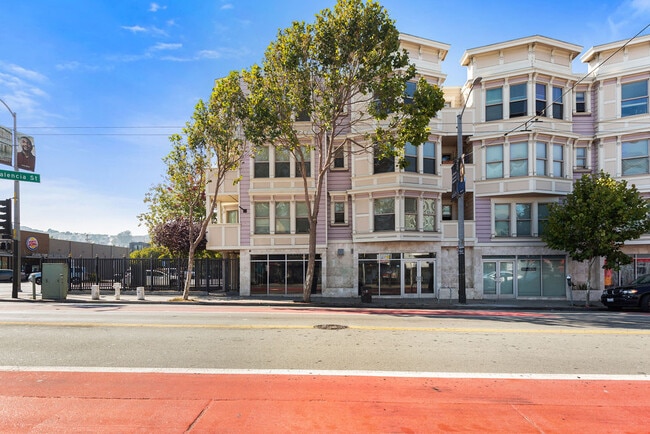
1699 Valencia St, San Francisco, CA 94110

Current Lease Availabilities
NEARBY LISTINGS FOR SALE OR LEASE
Property Detail
1699 Valencia St
San Francisco-Redwood City-South San Francisco, CA
A Mixed Use Condominium Plan For 3184 31
6574-047
San Francisco
Commercialcondominium
California
2024
47
2025
0.28 AC
025300
Bernal Heights
3,869 SF
San Francisco
DEMOGRAPHICS near 1699 Valencia St
1 Mile
3 Mile
5 Mile
2024 Total Population
73,193
490,166
844,429
2029 Population
68,056
452,393
781,660
Pop Growth 2024-2029
(7.02%)
(7.71%)
(7.43%)
Average Age
41
42
42
2024 Total Households
29,957
201,101
352,275
HH Growth 2024-2029
(7.58%)
(8.05%)
(7.78%)
Median Household Inc
$164,994
$121,983
$124,200
Avg Household Size
2.40
2.20
2.30
2024 Avg HH Vehicles
1.00
1.00
1.00
Median Home Value
$1,118,696
$1,088,009
$1,092,966
Median Year Built
1947
1950
1949
Nearby Places
- Restaurants
- Banks
- Shops
- Fitness
- Groceries
PUBLIC TRANSPORTATION
TRANSIT/SUBWAY
30Th Street And Dolores (CHURCH - San Francisco Municipal Railway (MUNI Metro), J Church - San Francisco Municipal Railway (MUNI Metro))
DRIVE
WALK
Distance
30Th Street And Dolores (CHURCH - San Francisco Municipal Railway (MUNI Metro), J Church - San Francisco Municipal Railway (MUNI Metro))
1 min
7 min
0.4 mi
Church And 29Th Street (CHURCH - San Francisco Municipal Railway (MUNI Metro), J Church - San Francisco Municipal Railway (MUNI Metro))
DRIVE
WALK
Distance
Church And 29Th Street (CHURCH - San Francisco Municipal Railway (MUNI Metro), J Church - San Francisco Municipal Railway (MUNI Metro))
1 min
8 min
0.4 mi
J Line Outbound (CHURCH - San Francisco Municipal Railway (MUNI Metro), J Church - San Francisco Municipal Railway (MUNI Metro))
DRIVE
WALK
Distance
J Line Outbound (CHURCH - San Francisco Municipal Railway (MUNI Metro), J Church - San Francisco Municipal Railway (MUNI Metro))
2 min
9 min
0.5 mi
Church St & 28Th St (CHURCH - San Francisco Municipal Transportation Agency)
DRIVE
WALK
Distance
Church St & 28Th St (CHURCH - San Francisco Municipal Transportation Agency)
2 min
9 min
0.5 mi
Church And 27Th Street (J Church - San Francisco Municipal Railway (MUNI Metro))
DRIVE
WALK
Distance
Church And 27Th Street (J Church - San Francisco Municipal Railway (MUNI Metro))
2 min
9 min
0.5 mi
COMMUTER RAIL
22Nd Street Caltrain Station Southbound (Express - Caltrain (Caltrain), Limited - Caltrain (Caltrain), Local Weekday - Caltrain (Caltrain), Local Weekend - Caltrain (Caltrain))
DRIVE
WALK
Distance
22Nd Street Caltrain Station Southbound (Express - Caltrain (Caltrain), Limited - Caltrain (Caltrain), Local Weekday - Caltrain (Caltrain), Local Weekend - Caltrain (Caltrain))
7 min
3.1 mi
22Nd Street (Caltrain - Caltrain (Caltrain))
DRIVE
WALK
Distance
22Nd Street (Caltrain - Caltrain (Caltrain))
7 min
3.1 mi
AIRPORT
San Francisco International
DRIVE
WALK
Distance
San Francisco International
19 min
11.7 mi
Metro Oakland International
DRIVE
WALK
Distance
Metro Oakland International
35 min
22.4 mi
Freight Ports
Port of San Francisco
DRIVE
WALK
Distance
Port of San Francisco
12 min
4.5 mi
Nearby Properties
Address
Land Use
TOTAL SIZE
Lot Size
Zoning
Address
Land Use
TOTAL SIZE
Lot Size
Zoning
1,015,000 SF
2.43 AC
RC4
Address
Land Use
TOTAL SIZE
Lot Size
Zoning
750,370 SF
3.25 AC
MBR3
Address
Land Use
TOTAL SIZE
Lot Size
Zoning
248,303 SF
4.35 AC
Address
Land Use
TOTAL SIZE
Lot Size
Zoning
717,234 SF
3.47 AC
UMU
Address
Land Use
TOTAL SIZE
Lot Size
Zoning
10.92 AC
Address
Land Use
TOTAL SIZE
Lot Size
Zoning
266,143 SF
4 AC
C-3-R
Address
Land Use
TOTAL SIZE
Lot Size
Zoning
885,581 SF
5.20 AC
M2
Address
Land Use
TOTAL SIZE
Lot Size
Zoning
508,714 SF
1.29 AC
C3R
Address
Land Use
TOTAL SIZE
Lot Size
Zoning
696,431 SF
0.97 AC
C3G
Address
Land Use
TOTAL SIZE
Lot Size
Zoning
1.52 AC
C3G
Address
Land Use
TOTAL SIZE
Lot Size
Zoning
1,424,230 SF
2.60 AC
C3G
Address
Land Use
TOTAL SIZE
Lot Size
Zoning
263,640 SF
0.72 AC
C3R
Address
Land Use
TOTAL SIZE
Lot Size
Zoning
2.74 AC
Address
Land Use
TOTAL SIZE
Lot Size
Zoning
313,306 SF
1.23 AC
WMUG
Address
Land Use
TOTAL SIZE
Lot Size
Zoning
314,826 SF
1.85 AC
MB-RA
Address
Land Use
TOTAL SIZE
Lot Size
Zoning
922,758 SF
1.94 AC
C3R
Address
Land Use
TOTAL SIZE
Lot Size
Zoning
10.92 AC
Address
Land Use
TOTAL SIZE
Lot Size
Zoning
393,918 SF
3.36 AC
WMUG
Address
Land Use
TOTAL SIZE
Lot Size
Zoning
24.37 AC
Address
Land Use
TOTAL SIZE
Lot Size
Zoning
241,659 SF
3.76 AC
Address
Land Use
TOTAL SIZE
Lot Size
Zoning
230,853 SF
3.76 AC
Address
Land Use
TOTAL SIZE
Lot Size
Zoning
302,084 SF
0.88 AC
MBO
Address
Land Use
TOTAL SIZE
Lot Size
Zoning
674,317 SF
3.36 AC
UMU
Address
Land Use
TOTAL SIZE
Lot Size
Zoning
319,119 SF
0.76 AC
Address
Land Use
TOTAL SIZE
Lot Size
Zoning
649,376 SF
0.93 AC
C3S
Address
Land Use
TOTAL SIZE
Lot Size
Zoning
222,000 SF
1 AC
MB-RA
Address
Land Use
TOTAL SIZE
Lot Size
Zoning
10.92 AC
Address
Land Use
TOTAL SIZE
Lot Size
Zoning
2.93 AC
Address
Land Use
TOTAL SIZE
Lot Size
Zoning
1.75 AC
C-3-O
Address
Land Use
TOTAL SIZE
Lot Size
Zoning
342,727 SF
1.36 AC
C3G
The World's #1 Commercial Real Estate Marketplace
Connect with us
© 2025 CoStar Group
The information above has been obtained from sources believed reliable. While we do not doubt its accuracy we have not verified it and make no guarantee, warranty or representation about it. It is your responsibility to independently confirm its accuracy and completeness. Any projections, opinions, assumptions, or estimates used are for example only and do not represent the current or future performance of the property. The value of this transaction to you depends on tax and other factors which should be evaluated by your tax, financial, and legal advisors. You and your advisors should conduct a careful, independent investigation of the property to determine to your satisfaction the suitability of the property for your needs.